
If you want those stunning Smoky Mountain views without feeling like you’ve just climbed Everest, you’re in the right place. I love a good adventure, but I’m also a fan of hikes that don’t require me to question my life choices halfway up. These are my favorite easy hikes in the Great Smoky Mountains National Park — the perfect mix of waterfalls, overlooks, and peaceful trails that give you all the mountain magic with minimal effort.
Whether you’re visiting Gatlinburg, Sevierville, or Pigeon Forge, these are trails you can actually enjoy without collapsing afterward. I’ve done them all myself, and I’ve included every single detail: where to park, what to bring, and even my personal “what I learned the hard way” notes.
See my Waterfall Hikes in the Smokies guide here.
Trail Overview
Location: Great Smoky Mountains National Park, near Gatlinburg
Distance: 2.4 miles round-trip
Elevation Gain: ~585 feet
Time to Complete: 1.5–2 hours at an easy pace
Trail Type: Out-and-back
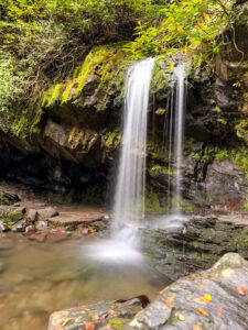
Grotto Falls is one of the park’s most popular trails — and for good reason. It’s the only waterfall in the Smokies you can actually walk behind, which makes it a must-do for first-time visitors.
Parking & Trailhead Info
The trail starts from the Trillium Gap Trailhead on the Roaring Fork Motor Nature Trail. Parking is limited and fills up quickly; I had to park about half a mile away (worth it, though). If you can, arrive before 10 a.m. to snag a spot. The Roaring Fork road is one-way, so plan your route accordingly. You’ll need a GSMNP parking tag ($5/day or $15/week).
Difficulty & Accessibility
This trail is easy to moderate, with some rocky and slippery sections near the falls. You’ll wind through an old-growth hemlock forest, pass several streams, and eventually reach the beautiful 25-foot waterfall.
Key Features & Highlights
Standing behind the waterfall is pure magic — misty, refreshing, and completely worth the damp hair. It’s also the perfect summer hike thanks to the cool pools at the base.

Timing & Seasonality
The trail is open year-round. Early mornings and weekdays are best for fewer crowds. In winter, it can get icy, so bring good traction.
Navigation Tips
Follow Trillium Gap Trail signs — it’s a straightforward route but can get muddy after rain.
Facilities & Amenities
No bathrooms or water at the trailhead, so plan ahead.
What to Bring
Hiking shoes with traction, water, light snack, and a rain jacket if you plan to stand behind the falls.
Safety & Things to Know
The rocks are slick, and this is bear country — keep your distance if you spot one.
My Experience
This hike hits that sweet spot: just long enough to feel like you accomplished something but not so hard that you’re wiped out. I started around noon (because I love my sleep), and even though it was busy, walking behind the waterfall felt like stepping into a hidden world. Totally worth it.
Trail Overview
Location: Tremont area, near Townsend, TN
Distance: 1.8 miles round-trip
Elevation Gain: ~400 feet
Time to Complete: 1–1.5 hours
Trail Type: Out-and-back
Spruce Flats Falls is a tucked-away gem that feels like a local secret. It’s short, peaceful, and rewards you with one of the prettiest waterfalls in the park.
Parking & Trailhead Info
Trailhead: Lumber Ridge Trailhead, behind the Great Smoky Mountains Institute at Tremont.
Parking: Small lot (free, but limited). A GSMNP parking tag is still required ($5/day or $15/week).
Navigation Tip: Follow signs for the Lumber Ridge Trail — it’s not marked as clearly as Laurel or Grotto, so keep an eye out for trail markers.
Difficulty & Accessibility
Easy to moderate. The trail is short but uneven, with roots, rocks, and a few tricky spots.
Key Features & Highlights
The waterfall cascades about 30 feet over mossy rocks into a quiet pool. It’s a beautiful, serene spot — especially after rainfall when the flow is strongest.
Timing & Seasonality
Open year-round, but especially pretty in spring with wildflowers or in fall with colorful leaves.
Navigation Tips
The path can get muddy and slippery, so wear good shoes.
Facilities & Amenities
No bathrooms or water at the trailhead, but the Tremont Visitor Center is nearby.
What to Bring
Water, sturdy shoes, and your camera.
Safety & Things to Know
The rocks around the falls are slick — don’t climb them.
My Experience
Spruce Flats Falls feels like a “locals know” hike. It’s quiet, short, and the kind of trail you’ll want to linger on. I loved how peaceful it was compared to the busier Gatlinburg hikes.

Trail Overview
Location: Great Smoky Mountains National Park, near Gatlinburg
Distance: 2.6 miles round-trip
Elevation Gain: ~314 feet
Time to Complete: 1–1.5 hours
Trail Type: Out-and-back
Laurel Falls is one of the Smokies’ most famous trails. It’s paved, it’s short, and it leads to an 80-foot waterfall that looks like something out of a postcard.
Parking & Trailhead Info
The trailhead is located 3.5 miles from the Sugarlands Visitor Center on Little River Road. The lot is small and fills fast. If it’s full, keep driving until you find roadside parking and walk back carefully. You’ll need a GSMNP parking tag.
Difficulty & Accessibility
Easy. The pavement makes it accessible for strollers with good wheels and perfect for beginners.
Key Features & Highlights
An 80-foot, two-tiered waterfall with a footbridge crossing between the upper and lower sections. The mountain laurel blooms in late spring and gives the falls its name.
Timing & Seasonality
Open all year. Go early or late for fewer crowds. Spring brings the blooms; fall brings the colors.
Navigation Tips
Stay on the paved path — there are steep drop-offs near the falls.
Facilities & Amenities
No bathrooms or water at the trailhead; the closest are at Sugarlands Visitor Center.
What to Bring
Good shoes (the pavement can get slick), water, and a camera for the bridge photo.
Safety & Things to Know
Keep a close eye on kids near the falls — those drop-offs are no joke.
My Experience
This is my go-to recommendation for anyone who says, “I’m not a hiker.” It’s short, easy, and delivers a huge payoff. Standing on that bridge between the upper and lower falls never gets old.
Overview
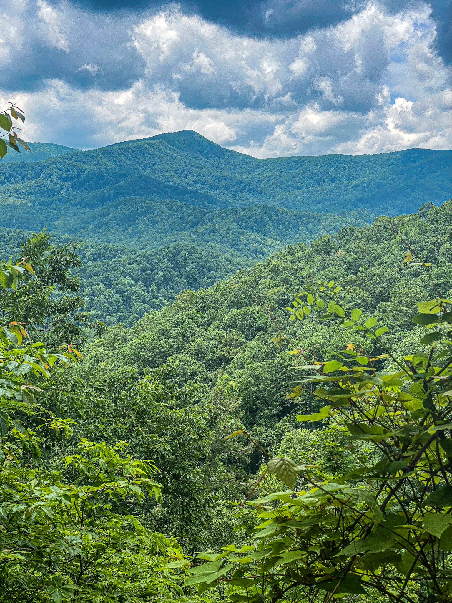
Kuwohi, formerly known as Clingmans Dome, is the highest point in the Great Smoky Mountains National Park at 6,643 feet. It’s also the highest point in Tennessee and the third-highest east of the Mississippi. In 2024, it officially reclaimed its Cherokee name “Kuwohi,” which means “mulberry place.”

Trail & Tower
The hike to the top is short but steep — a 0.5-mile paved path that leads to a 54-foot observation tower. From there, you get 360-degree views stretching more than 100 miles on a clear day.
Access & Seasonality
You’ll reach it by turning off Newfound Gap Road onto Kuwohi Road and following it for seven miles. The road is open seasonally (April 1–December 1). When it’s closed, you can hike or bike up if you’re feeling ambitious.
Environment & Conditions
Because of its high elevation, it’s usually 10–20 degrees cooler than Gatlinburg. Fog, wind, and sudden weather changes are common, so bring layers.
History & Cultural Significance
Kuwohi is a sacred site to the Cherokee people and an important part of their heritage. It’s also the site of a 1946 B-29 crash.
Tips for Visitors
Arrive early for parking, bring water and rain gear, and take your time on the climb — it’s short but steep.
My Experience
Even if the summit is fogged in (which it often is), it’s still one of those places you have to see at least once. The drive alone is worth it, and the views on a clear day are jaw-dropping.
See my Overlooks in the Smokies guide here.
Trail Overview
Location: Near the Sugarlands Visitor Center
Distance: 0.75 miles round-trip
Elevation Gain: Minimal
Time to Complete: 20–30 minutes
Trail Type: Out-and-back
Cataract Falls is one of the easiest waterfalls to reach in the Smokies — perfect if you’re short on time or hiking with little ones.
Parking & Trailhead Info
Start right behind the Sugarlands Visitor Center. There’s a large parking lot with plenty of space.
Difficulty & Accessibility
Easy. The trail is short and flat.
Key Features & Highlights
A shaded, peaceful path along a creek ending at a 25-foot waterfall.
Timing & Seasonality
Open year-round. Especially nice in spring and summer when the forest is lush.
Navigation Tips
Follow the Fighting Creek Nature Trail signs — it’s simple and well-marked.
Facilities & Amenities
Bathrooms, water fountains, and maps are available at the Visitor Center.
What to Bring
Just comfortable walking shoes.
Safety & Things to Know
The rocks near the falls are slippery.
My Experience
This is the definition of a quick and easy stop — not an all-day adventure, but the perfect stretch-your-legs trail before heading deeper into the park.
Overview
Cades Cove is a wide, scenic valley surrounded by mountains, filled with wildlife, historic cabins, and open fields. The 11-mile one-way loop can be driven or biked and is one of the most beautiful drives in the Smokies.
Driving the Loop
It might only be 11 miles, but you’ll want at least 3–4 hours to enjoy it. There are plenty of pull-offs for photos, historic churches, and even a few short hikes. Wildlife sightings are common — you’ll probably spot deer and maybe even a black bear (from a distance, of course).
Biking the Loop
If you prefer biking, certain mornings in summer are vehicle-free — it’s an incredible experience to have the road to yourself. Rentals are available at the campground store for around $15/hour.
Tips for Visiting
Go early to beat the crowds. Bring water, snacks, and your camera. Cell service is limited, so download maps in advance.
My Experience
Cades Cove is one of those places that never looks the same twice. Morning fog, fall color, or even winter frost — it’s always gorgeous.
See my Spend a Week in Gatlinburg and Sevierville guide here.
Trail Overview
Location: Near Sugarlands Visitor Center, just outside Gatlinburg
Distance: 0.5 miles round-trip
Elevation Gain: None
Time to Complete: 20–30 minutes
Trail Type: Loop, paved
Parking & Trailhead Info
There’s a small lot right off Newfound Gap Road, easy to find just past Sugarlands Visitor Center.
Difficulty & Accessibility
Very easy. It’s one of the only wheelchair- and stroller-accessible trails in the park.
Key Features & Highlights
The trail follows the West Prong of the Little Pigeon River with bridges, interpretive signs, and forest views.
Timing & Seasonality
Open year-round. In spring and summer it’s lush and green; in fall, the colors are amazing.
Navigation Tips
It’s a short, paved loop — you can’t get lost.
Facilities & Amenities
Bathrooms, maps, and water fountains are available at Sugarlands Visitor Center.
What to Bring
Just comfortable walking shoes and maybe a camera.
Safety & Things to Know
It’s extremely safe and family-friendly; just watch for slick spots after rain.
My Experience
This little loop gives you that full Smoky Mountain vibe — forest, river, and history — all in under half a mile. It’s peaceful, easy, and perfect for families or anyone who wants a quick nature fix without breaking a sweat.
If you’re like me and you love being in nature but don’t necessarily want to summit a mountain to prove it, these are the perfect Smoky Mountain hikes. They’re short, scenic, and full of that misty, magical charm that makes this park so special.
The best part? You can easily fit one or two of these into any Smoky Mountain itinerary — whether you’re visiting for a day or a full week.
Always check the park service site to see the most updated information. Also see my Top 5 Activities in Gatlinburg guide here.
So grab your hiking shoes, snag your parking tag, and go explore. The Smokies have a way of reminding you that sometimes the easiest trails are the ones that leave the biggest impression.
Let’s talk about when to actually book that Dubai trip you’ve been pinning for two years. I get asked this constantly, so here’s the honest breakdown: October through April is your window. Anything outside that and you’re basically touring in a sauna!
October and November give you warm days and cooler nights, which is basically the sweet spot for wandering around without melting. December through February is peak season: gorgeous weather. March and April are the quiet insider pick, right before summer heat shows up and ruins everyone’s plans.
Saving this for later? That’s what it’s here for. Full breakdown linked in bio.

If you’re chasing energy, beaches, nightlife, and nonstop luxury, Dubai takes the crown. If you’re craving culture, iconic architecture, and meaningful landmarks at a slower pace, Abu Dhabi shines.🤍
My advice? Base yourself in Dubai and do Abu Dhabi as a day trip! The perfect balance of excitement and culture in the UAE.
Want the full breakdown? Check out my Dubai and Abu Dhabi guide for tips, itineraries, and must-sees!
I do not like seafood. 🐟 So when I booked a tasting menu at a restaurant built around aquarium walls at Atlantis The Palm, I was nervous.
Ossiano sits underwater fish gliding past the whole meal, moody lighting, the kind of room that makes you lower your voice without meaning to. It’s not cheap, and it’s not trying to be. You’re paying for the entire experience.
Here’s the honest part: they have a vegetarian tasting menu, and I assumed it would be an afterthought. It ended up in my top five meals of all time. Course after course, the same care and precision as the seafood-forward menu everyone comes for. They even swapped in a steak for the main and it still felt cohesive with everything around it.
By course four you’re full. They bring out three more breads anyway. I ate all of it. No regrets.
Small detail that stuck with me my dress was black, so they swapped my napkin from white to black without me asking. That’s the kind of thing that tells you everything about a place.
Full breakdown of the menu, the vegetarian option, and what to expect linked in bio.
Dubai is all skyline until you drive an hour into the dunes and it goes completely silent. Bab Al Shams was that shift for us: slower, quieter, more intentional than anything we did in the city.
If you want nightlife or walkable everything, this isn’t your stop. But if you want a night that feels like a reset, it delivers, polished service, food I’m still thinking about, and a setting that never tries too hard.
Full review (and whether it’s worth adding to your Dubai itinerary) is linked in bio. 🏜️
I flew @emirates economy to Dubai fully expecting to just survive the flight. We booked seats by the exit row — @bradplummer1 got the legroom (he’s 6’7”), I got a normal seat right next to him, and it saved us money over booking two extra-legroom seats. Smart trick if you’re traveling with someone who needs the extra space and you don’t.
The food alone earned this post. Warm chicken, a Waldorf salad that actually tasted fresh, real butter on the roll, and a breakfast spread that put most airport brunches to shame. Add in the twinkling-star cabin lighting once dinner wrapped, and it felt less like a flight and more like the trip had already started.
Not everything was perfect — the wifi didn’t work for me at all, so if you’re planning to get work done in the air, download what you need beforehand. But that was the only miss in an otherwise excellent long haul.
If you’ve got Emirates lounge access in Dubai, use it. Showers, buffets, quiet corners to nap it makes the layover feel like a reset instead of a slog.
Full review seats, food, lounge, and the wifi situation is on the blog. Link in bio. ✈️

Follow @travelwithwendyplummer for Beautiful Beach Destinations, City Guides, Foodie Spots, and Luxury Hotel Recommendations.
